

Abstract
The 2026 multi-domain conflict has confirmed that a new conduct of warfare has arrived, one whose contours were already visible in the Russia-Ukraine war, in Operation Spider Web and the Kerch Bridge attack. This paper explores the future of Iran’s grand strategy and proposes options to survive the rapidly approaching era of AI innovation and space capabilities. The reader should note that these are prescriptive recommendations.
Geopolitical scholars agree on one basic premise: Iran’s geography is unique. Iran occupies the exact hinge point between the two most consequential theories in classical geopolitics: Halford Mackinder’s Heartland thesis and Alfred Thayer Mahan’s sea-power doctrine. For Mackinder, the geographical pivot of world history was the Eurasian interior, insulated from maritime pressure and decisive for any power that could hold it (Mackinder, 1904). For Mahan, national greatness derived from maritime supremacy, the command of open sea lanes built on naval strength, merchant capacity, and overseas basing (Sumida, 1999, as cited in Gray & Sloan, 1999). Iran does not qualify as a sea power in this sense; instead, it holds a more asymmetric position: the capacity to threaten a single chokepoint, the Strait of Hormuz, which is strategically consequential precisely because Mahan’s sea-power states depend upon it. Iran sits at the intersection of both logics: possessing continental depth and maritime chokepoint command simultaneously.
However, Iran’s geography is not the iron determinant that classical geo-determinism claimed it to be. From Friedrich Ratzel’s organic state theory to the early readings of Mackinder, the geo-determinist tradition argued that physical terrain fixes the strategic destiny of states that mountains, plateaus, and straits mechanically produce political outcomes regardless of human agency (Sloan, 1999, as cited in Gray & Sloan, 1999). This paper does not accept that framing. Indeed, Mackinder himself was at pains to resist this reading, noting that “the actual balance of political power at any given time is, of course, the product, on the one hand, of geographical conditions, both economic and strategic, and on the other hand, of the relative number, virility, equipment, and organization of the competing peoples” (Mackinder, 1904, p. 437). Nor does this paper accept the opposite extreme: that precision-guided munitions and satellite networks have rendered terrain strategically obsolete. Those who insist on the continued relevance of geography in military planning are not arguing that mountains block missiles. They argue that geographic features raise the threshold of vulnerability, increase attackers’ costs, compress enemy logistics, and degrade the operational calculus of any invading force (Gray, 1999, as cited in Gray & Sloan, 1999). This is a well-established line of reasoning in strategic studies, and it remains valid. What this paper argues is that this logic is incomplete on its own. Technology does not transcend geography; as Colin Gray observes, “to plan and act globally is not to transcend geography, in fact quite the reverse” (Gray, 1999, p. 161, as cited in Gray & Sloan, 1999). It renegotiates geography’s terms. The mountains of Iran are still highly valuable not as passive physical walls to stop tanks, but as natural geological armor required to shield and sustain the digital and orbital power networks on which twenty-first-century command depends. The challenge for Tehran’s policymakers is to embed this geological foundation inside a coherent architecture of cyber, satellite, and informational capability. Iran’s geography is an asset with an expiry date, and that date is determined by the pace at which Tehran converts its permanent structural advantages into sovereign AI and space power.
Iran’s strategic problem is not a capability gap; it is a conversion gap. Every idea below is not simply “what Iran could do” but “how Iran converts what it already has into what it currently lacks.” The concept of the longue durée offers the appropriate analytical frame: geography belongs to the slowest tier of historical time, the layer of mountains, seas, and climate that conditions all subsequent political action for centuries without itself visibly changing (Braudel, 1949, as cited in Sloan, 1999, in Gray & Sloan, 1999). Based on this concept, a large-scale ground invasion remains among the most logistically demanding operations conceivable. Yet the question is how to use geographical structure to create deterrence, defense, and offense. Mackinder and Mahan are not in agreement about what this means. Mackinder prizes depth and inaccessibility; Mahan prizes exposure and projection (Mackinder, 1904; Sumida, 1999, as cited in Gray & Sloan, 1999). A state that is simultaneously deep and exposed as Iran is sits at the convergence of two opposing strategic demands. The Zagros range and the Iranian plateau protect Tehran from ground invasion but cannot alone protect a chokepoint located along Iran’s own coastline from naval pressure and precision airstrikes. Conversely, command of Hormuz projects Iranian leverage across the global economy but also makes every tanker and every refinery within Iranian territory a target for adversaries who wish to sever that leverage before it can be exercised. It reveals both strategic advantage and strategic exposure.
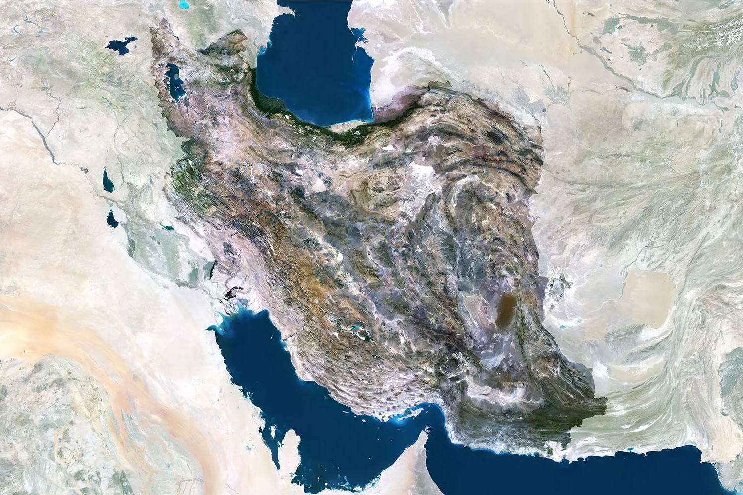
As Colin Gray states, “geography cannot be an optional extra for consideration by the strategic theorist or planner, because it drives the character and potential contemporary reach of tactical, hence operational, prowess” (Gray, 1999, p. 161, as cited in Gray & Sloan, 1999). Strategy, for Gray, is the dialogue between policy and military power, and geography forms the “grammar” within which that dialogue must be conducted not the sentence it produces. New technologies, Gray argued, alter what geography means without abolishing it: “to plan and act globally is not to transcend geography, in fact quite the reverse” (Gray, 1999, p. 161, as cited in Gray & Sloan, 1999). The rise of multi-domain conflict is precisely such a technological alteration, what Braudel would call a conjoncture, a medium-term structural shift that changes what the longue durée of terrain and straits delivers to those who hold them (Braudel, 1949, as cited in Sloan, 1999, in Gray & Sloan, 1999). The 2026 multi-domain campaign against Iran demonstrated this with empirical precision. GPS spoofing and electronic jamming across the Persian Gulf and Iranian airspace caused widespread navigation failures for both civilian and military platforms. Iran’s integrated air defense architecture was degraded across its early warning network before aircraft arrived over the target. The Zagros Mountains still prevented a decisive ground campaign, but the geographic depth that protected the regime’s physical survival could not protect it from vertical escalation through the info sphere and the electromagnetic spectrum. Geography was not transcended; it was bypassed from above.
Geological Deterrent Doctrine: From Missile Cities to Digital Depth
Iran’s first strategic priority should therefore be the deliberate, institutionalized conversion of its terrain into a layered shield not merely for missiles, but for the informational and digital architecture upon which twenty-first-century command depends. Call this the Geological Deterrent Doctrine. Its logic is simple and already proven in the military domain. Iran did not leave its most sensitive military assets above ground, and it must not leave its most sensitive digital assets there either.
The IRGC’s subterranean missile cities are the proof of concept. According to IRGC former Aerospace Force Commander Hajizadeh, missiles are buried at depths of up to 500 meters inside mountain massifs across all Iranian provinces, stored vertically within rail-linked launch systems and hardened storage networks (Wikipedia, 2015; Al Jazeera, 2026). During the 2026 campaign, these facilities proved resilient: the adversary could blind Iran’s radar networks, jam its GPS, and degrade its command architecture, but it could not collapse what the mountain was holding (CNN, 2026). The logical extension, which this paper proposes as a prescriptive recommendation, is a National Underground Digital Infrastructure Program: a deliberate policy of relocating strategically sensitive digital systems below ground, including hardened data centers, AI-processing nodes, satellite ground-control stations, communication nodes, and a buried national fiber backbone designed to preserve command, communication, and data continuity during conflict. What Iran has already done for missiles, it must now do for information. Geography would no longer protect only the strategist’s body it would protect the strategist’s mind.
The objection is predictable: Fordow exists, and it was still targeted. This misreads the lesson on two counts. First, the job of the strategist is not to make infrastructure invisible it is to make its destruction so costly that the adversary rationally chooses not to attempt it. A distributed network of hardened nodes buried across the Zagros and Alborz, numerous enough and deep enough that no strike package can disable them all, transforms the cost-benefit calculus of any attacker (Gray, 1999, as cited in Gray & Sloan, 1999). Second, the Geological Deterrent Doctrine works through credible dispersal, not secrecy. The deterrent value is not that the infrastructure is hidden; it is that destroying it is structurally impossible at any operationally acceptable cost. The mountain does not need to be secret. It needs to make invasion costly.
The strategic implication is therefore direct and prescriptive. Iran must extend the principle of geographic agency from the military domain into the informational domain. The longue durée of terrain must become the foundation of the conjoncture of digital power. The same mountains that have made Iran unconquerable by ground armies for three millennia can make its command, communication, and data infrastructure unconquerable by airpower. Geological depth becomes digital depth.
Asymmetric AI Innovation: The Shahed Model Applied
Iran’s second grand strategic line should be asymmetric AI innovation. The point is not to compete with the United States, China, or Israel in general-purpose artificial intelligence. A sanctions-constrained state cannot easily build foundation models, sovereign semiconductor supply chains, or hyper scale cloud infrastructure. But this does not mean Iran must remain a passive technological subject. The correct lesson is not to imitate Silicon Valley. It is to extend the logic of the Shahed.
The Shahed-136 matters because it revealed a method of strategic innovation under constraint. Iran did not dominate aerospace technology. It identified one narrow capability, industrialized it under pressure, and forced wealthier adversaries to spend disproportionately to counter it. That is the model Iran should carry into the AI domain. The goal should not be total mastery of artificial intelligence as a whole, but disciplined mastery of one niche within it, where limited resources can produce disproportionate strategic effect. In the AI domain, power does not always belong to the state with the largest model, the biggest data center, or the most advanced semiconductor supply chain. It can also belong to the actor that identifies the most strategically useful application and masters it before others adapt. For Iran, this means searching for narrow AI applications swarm coordination, electronic-warfare automation, cyber-intrusion detection, and satellite-image analysis where domestic engineering can produce operationally decisive tools. The attainability of this approach is not speculative. Ukraine a resource-constrained state under active attack built AI-assisted drone navigation systems capable of operating under GPS jamming, developed through iterative engineering cycles measured in weeks rather than years (Hird et al., 2026, as cited in Small Wars Journal, 2026). Iran has already signaled institutional intent: its 2024 Defense Minister nominee formally proposed AI integration across the drone fleet specifically to enable swarm operations (Bielby, 2024). Furthermore, in March 2024 Iran and Russia signed a memorandum of understanding on AI development explicitly oriented toward drone and military technology enhancement (Breaking Defense, 2025). Strategic necessity, as the Shahed demonstrated, can outperform financial advantage when focus replaces ambition. This is the Asymmetric AI Innovation doctrine.
The future battlefield will be saturated by cheap, expendable, AI-assisted unmanned systems. The decisive state will not simply be the one that launches the most drones. It will be the one that defeats drone swarms cheaply (Vision of Humanity, 2026). Iran should therefore focus on AI-enabled counter-swarm defense: systems that can detect, classify, prioritize, and help neutralize unmanned attacks faster than human-operated defenses alone. This applies the Shahed logic in reverse. What the Shahed did to the economics of air defense, Iran must now do to the economics of drone attack. The objection that Iran lacks advanced chips and deep AI infrastructure misunderstands the nature of asymmetric innovation. Iran does not need AI in general. It needs battlefield-specific AI at the edge: smaller models, narrow tasks, ruggedized hardware, systems trained for the specific defensive problems Iran actually faces. Operational drone experience is not merely a military record; it is a strategic data asset that no sanctions regime can confiscate. The chip shortage is a constraint Iran must manage. The data advantage is a strategic asset Iran has not yet chosen to spend.
This doctrine does not stand alongside the Geological Deterrent Doctrine it completes it. Underground data centers and mountain command nodes are not enough if they can be isolated, blinded, jammed, or overwhelmed by swarms. Geological depth requires algorithmic defense. The mountain protects the infrastructure; AI protects the mountain. Together, they constitute what this paper calls geo-technological depth, and without the algorithmic layer, the geological one is structurally incomplete.
Sovereign Orbit: The Extension of Iranian Resilience
Hormuz’s strategic power does not come from Iran closing it. It comes from the fact that every adversary must plan around the possibility that Iran could. Orbital infrastructure operates by the same coercive logic not because an orbital lane can be blocked, but because a state that persistently monitors carrier groups, missile batteries, logistics hubs, and maritime traffic in its own theatre forces adversaries to factor Iranian visibility into every operational plan before the first shot is fired. This is not the ambition of a Proliferated Warfighter Space Architecture or a Guowang constellation; those are instruments of great-power force projection at global scale. What Iran needs is narrower and more achievable: sovereign surveillance of its own theatre, independent communications resilient against the GPS jamming that degraded Iranian operations in 2026, and space situational awareness over the Persian Gulf and Arabian Sea. Iran does not need an orbital empire. It needs an orbital layer over its own theatre.
Iran has already begun this work. The Nahid-2 telecommunications satellite and the Pars-1 Earth-observation platform confirmed by Iran’s Space Research Center and scheduled for launch in late 2025 and early 2026 constitute the embryo of a layered architecture that, if completed and protected, would serve precisely this purpose (Mehr News Agency, 2025; Orbital Today, 2025). Nahid-2 carries KU/X/UHF-band payloads at a 500km orbit, while Pars-1 provides multispectral, SWIR, and thermal infrared imaging at sub-2.5m resolution (Orbital Today, 2025). The targeting of Iran’s space facilities in the 2026 conflict suggests that adversaries already recognize the military relevance of sovereign Iranian orbit. As Bowen argues, spacepower is not domination from above it is infrastructure connected to Earth, valuable only when it produces terrestrial effects (Bowen, 2020). The constellation does not need to threaten adversary satellites. It needs to survive long enough to maintain coverage. That is why dispersal, redundancy, and geo-technological depth are the correct design principles.
The geographic foundation of this strategy is Chabahar. As Iran’s most southerly ocean-facing launch geography, positioned on the Arabian Sea and less vulnerable to a Hormuz-centered blockade, Chabahar offers southward trajectories over open Indian Ocean waters resolving the overflight constraints that limited sun-synchronous orbit access from Semnan, and opening a credible pathway toward the reconnaissance orbits that matter most (Bowen, 2020). Nahid-2 and Pars-1 were launched aboard Russian Soyuz vehicles because Iran’s domestic launch infrastructure remains limited (Mehr News Agency, 2025). Chabahar is therefore not the solution to Iran’s orbital dependence, but the architecture through which that dependence could gradually be reduced. As the southern anchor of the International North-South Transport Corridor, it draws the partner interest, logistical connectivity, and maritime access that could accelerate this transition. A power that can project by sea, by land corridor, and eventually into orbit from a single node beyond the immediate reach of a Hormuz closure is not merely trapped by its geography. It is beginning to build what classical geography alone could never guarantee.
Geo-technological depth begins in the mountain. It is completed in orbit.
Conclusion
Iran’s geography has never determined its fate. It has always set the terms on which agency is either seized or forfeited. The twenty-first century has not changed this logic it has raised the price of exercising it, demanding that mountains become data bunkers and straits be anchored to sovereign orbital infrastructure if they are to remain assets rather than liabilities.
The Strait of Hormuz will not remain an inexhaustible strategic card. As Persian Gulf States accelerate pipeline bypass capacity, as energy transition reduces global hydrocarbon dependence, and as adversaries develop the multi-domain suppression capabilities to neutralize Iran’s A2/AD posture from the electromagnetic spectrum downward, the coercive credibility of Hormuz will decline. The strategic portfolio must be rotated now. New cards hardened digital infrastructure, asymmetric AI innovation, a resilient satellite architecture, and niche cyber capabilities must be developed while the old cards still hold their value, because the window in which they can fund that development will close. Iran’s future strategic position will be determined not by what it inherits from geology but by what it builds inside it.
*The views and opinions expressed in articles published in this section are those of the individual authors and do not necessarily reflect the official positions or views of PAIAB.
References
- Al Jazeera. (2026, March 17). Inside Qeshm, Iran’s underground missile fortress and geological marvel. https://www.aljazeera.com/features/2026/3/17/inside-qeshm-irans-underground-missile-fortress-and-geological-marvel
- Bielby, K. (2024, August 20). Iran’s nominated Defence Minister proposes use of AI to enable drone swarm operations. Unmanned Airspace. https://www.unmannedairspace.info
- Bowen, B. E. (2020). War in space: Strategy, spacepower, geopolitics. Edinburgh University Press.
- Breaking Defense. (2025, January 7). Inside Russia’s plan to build autonomous drone swarms. https://breakingdefense.com/2025/01/inside-russias-plan-to-build-autonomous-drone-swarms/
- (2026, March 19). CNN investigates: Iran’s underground missile cities. https://www.cnn.com/2026/03/20/world/video/investigates-iran-underground-missile-cities-digvid
- Gray, C. S., & Sloan, G. (Eds.). (1999). Geopolitics, geography and strategy. Frank Cass.
- Mackinder, H. J. (1904). The geographical pivot of history. The Geographical Journal, 23(4), 421–437. https://doi.org/10.2307/1775498
- Mehr News Agency. (2025, September 26). Iran to launch two satellites in coming months. Mehr News Agency. https://en.mehrnews.com/news/237017/Iran-to-launch-two-satellites-in-coming-months
- Orbital Today. (2025, February 5). New Iran’s satellites, Pars-1, Pars-2, and Navak, were unveiled. https://orbitaltoday.com/2025/02/06/iran-unveils-3-new-satellites-on-national-space-technology-day/
- Small Wars Journal. (2026, May 3). Ukraine bets on AI. https://smallwarsjournal.com/2026/05/03/ukraine-bets-on-ai/
- Vision of Humanity. (2026, April 21). How AI is rewriting the rules of modern warfare. https://www.visionofhumanity.org/how-ai-is-rewriting-the-rules-of-modern-warfare/
- (2015). Iranian underground missile bases. https://en.wikipedia.org/wiki/Iranian_underground_missile_bases